
The Orenda: Description and back cover blurb
The Orenda, by Joseph Boyden A historical epic about a clash of nations as seen through the eyes of a Huron man, an Iroquois woman, and a French missionary. It was nominated for many rewards when it came out and remains highly regarded.
The Back Cover Blurb:
"In the remote winter landscape a brutal massacre and the kidnapping of a young Iroquois girl violently re-ignites a deep rift between two tribes. The girl’s captor, Bird, is one of the Huron Nation’s great warriors and statesmen. Years have passed since the murder of his family, and yet they are never far from his mind. In the girl, Snow Falls, he recognizes the ghost of his lost daughter, but as he fights for her heart and allegiance, small battles erupt into bigger wars as both tribes face a new, more dangerous threat from afar.
Traveling with the Huron is Christophe, a charismatic missionary who has found his calling among the tribe and devotes himself to learning and understanding their customs and language. An emissary from distant lands, he brings much more than his faith to this new world, with its natural beauty and riches.
As these three souls dance with each other through intricately woven acts of duplicity, their social, political and spiritual worlds collide - and a new nation rises from a world in flux."
Comments
This is just to remind folks we'll be discussing The Orenda by Joseph Boyden at the end of the month.
I'm about 1/4 the way through, realising that I know almost nothing about the history and geography of the book, so am looking forward to some Canadian input on this") It's densely written - this is not a criticism but an observation - and so not a quick read.
It's densely written - this is not a criticism but an observation - and so not a quick read.
I've finished it. I wouldn't call it "dense", so that bodes well for an interesting discussion!
As we're reading (or thinking back on the read) I thought I'd post a few photos of some re-created historic settlements.
This first batch is from Tsiionhiakwatha Archaeological Site near St. Anicet, Quebec, on the south side of the St Lawrence river, close to the New York State border.
https://www.sitedroulers.ca/site-en/
It's an Iroqoian village, and very similar to the Wendat village described in the book. The place is surrounded by a palisade which I think is made from what we call Eastern White Cedar (and you might call Arborvitae in the UK - Thuja occidentalis).
A portion of the palisade overlaps at the entrance. So to enter the village, you need to walk through a narrow section with peles on both sides. After 20 or 30', the narrow path switches back, like a hair-pin. Above the path are platforms on which defenders can stand.
There are longhouses and other buildings inside the palisade, as well as drying racks and so on.
In the story, they also visit Quebec, shortly before the death of Samuel de Champlain in 1635. Champlain founded the permanent French colony of Quebec in 1608. Before that, his base had been at an earlier French trading fort called Port Royal, which he founded with a merchant named De Mons, in what is now Nova Scotia. He lived there from 1605 to 1607, during which time he continued to explore, as far south as Cape Cod.
I visited the re-created Port Royal this summer. These pictures should give an idea of what the settlement at Quebec might have looked like (only without the cliffs). This included a trading counter (the last picture) where trappers could bring their furs to be exchanged for European goods.
https://en.wikipedia.org/wiki/Port-Royal_National_Historic_Site
Excellent photos, thanks. They really illustrate what's in the book.
The palisade is different from what I imagined. The one pictured wouldn't stop arrows, but the book suggested that people could shelter safely behind a palisades, implying it was a solid wall. I don't know if that's an error by the author, or just showing off variation in fortifications at the time.
https://www.geonmagazine.com/our-history/history-history/iroquoian-village-near-crawford-lake
There’s another historic site specific to the Wendat called Ste Marie Among The Hurons, which is specifically a Jesuit missionary settlement, so later that our time period. Judging by the pictures, the palisade is a little more substantial, and maybe made from spruce or fir peles instead of thuja.
https://en.m.wikipedia.org/wiki/Sainte-Marie_among_the_Hurons
The SMAH website has a page on Wendat culture.
http://www.saintemarieamongthehurons.on.ca/sm/en/HistoricalInformation/TheLifeoftheWendat/index.htm
Yes, these photos are very helpful, not least because they highlight the qualitative difference between the Huron (and other similar tribal) palisades and the French ones.
I confess to still being rather baffled by the geography and history of the book's events - and having looked up a couple of internet sites am still baffled... I originally thought that the setting was north of the Great Lakes in (what is now) Canada, but then maps seem to show the Huron and Iroquois territories as extending a lot further south, well into (what is now) the US. Then I sort-of made a connection with Last of the Mohicans (which tribe was, I have read, allied with the Hurons) but then that is set (I think) east of the Appalachians and so nowhere near the Great Lakes.
Timewise I was expecting to see the British and/or Dutch on the scene as antagonists to the French, and so presumably supplying the Iroquois, but they didn't seem to be in the picture at all - maybe the book is set too early for all that?
Anyway, I'm sure a lot of this will come out in discussion but I'd be curious to know if others found that the author assumed a high level of reader familiarity with the context.
To give some geographical context. The Wendat land, Wendake, is located west of Lake Simcoe and south of Lake Huron, but not as far south as Lake Ontario. The Wendat were Iroquoian people, and related to the six nations of the Iroquois, which were mainly located below the St Laurence River/ Lakes Ontario and Erie. North of Lake Ontario were the Mississaugas, an Anishnaabe tribe. In the book, Gosling is Anishnaabe. Algonquins and Ojibwe and Chippewa were also Anishnaabe. Someone in the book calls both the Wendat and Haudenosaunee ‘People of the Longhouse’, pointing to their shared heritage.
Bird’s village is close to Lake Huron, and particularly Georgian Bay (which most modern Ontarians see as a separate body of water from Lake Huron). They speak often of the ‘Great Sweet Water Sea’. At one time, Bird tells how Anishnaabe elders spoke of how “the waters open to even bigger waters and then to a great inland sea”. This is a reference to how Georgian Bay opens onto Lake Huron, and Lake Superior lies beyond.
To get to Quebec, they would take one of several River systems down to Lake Ontario, then head east. I think the most likely rote is the one covered by the modern Trent-Severn canal, then to follow the north shore of Lake Ontario and down the St Lawrence.
They might also come down closer to Toronto, down the Humber or Don river, or even go down the St Clair River. There are several places in Ontario called ‘Carrying Place’ which points to their importance as Portage Routes between river/lake systems.
But Im pretty sure the Trent Severn is being referred to for Bird’s second mission in the middle of the book. Some of these routes would bring them into contact with the Iroquois, and I guess we’re specifically talking Seneca (the tribe of Snow Falls), whose territory was between the Genesee River and lake Canandaigua in upstate New York, not far from where Clash’s wife Ellen hails.
Although the Iroquois were generally located in what’s now the US, many were later granted lands in Canada by the English in exchange for their help in fighting the French. The Six Nations of the Credit reserve (Near Brantford, Ontario) is a Seneca territory. Near Montreal is Kanawake, a Mohawk reserve. And there are many others.
Timewise, we’re looking at the 1630s. This area was still French settled. The English and Dutch were confined to the east coast and the English were also in the far north (Hudson’s Bay and Labrador) and Newfoundland, and in Virginia. The centre was French, up the St Lawrence River through the Great Lakes and down the Mississippi. Between 1759 (Battle of Quebec) and 1803 (Louisiana Purchase) this changed. The French influence is still seen in many place-names, like Duluth, St Clair, St. Louis, Detroit, Louisiana, Baton Rouge, New Orleans, and many more.
The Iroquois were allied to the English, the Algonquin and Huron to the French. The most famous conflicts are still in the future, but if I remember, the French settlement at Port Royal was destroyed by English coming up from New England or New York.
The recreated site I mentioned above, Sainte Marie Among the Hurons (possibly the mission Christophe founded?) is near Midland, Ontario.
Technically, this is Deer Clan territory.
I’m not sure where Bear Clan territory is, but I’m guessing Wasaga, Collingwood, Owen Sound areas.
I knew where the Wendat lived, and so guessed Georgian bay was the Great Sweet Water Sea. I am very familiar with the Iroquois - I'm actually playing an Oneida NPC in Elizabethan England in my Elizabethan Supers game. The tribe near Syracuse New York, where my wife is from, is the Onondaga. The Oneida are from further east, South of Lake Ontario and the St. Lawrence - the cities of Rome and Utica NY are in their homelands.
I worked out (with the help of Google Maps) part of my geographical confusion. I realised that my mental map of the US was sort of like this:

and my newly revised mental map looks more like this:
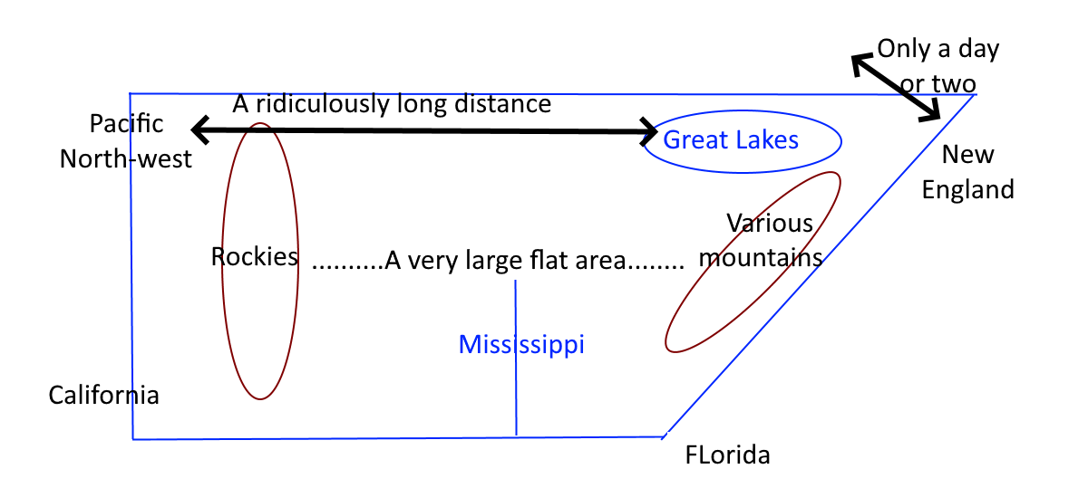
which (however much still bizarre) makes a lot more sense of things to me...
@RichardAbbott To help with your map of North America: The norther border of the US west of the Mississippi is about 500 miles north of the northern border at Lake Erie, the southernmost Great Lake.
Lake Superior is quite far north of Lakes Erie and Ontario, so the oval of the Great Lakes should be at an angle from NW to SE, then E, not just W to E.
New England is south of the Great Lakes, so there is a quite a large land east of the Great Lakes that is north of New England - it was called New France, now Quebec, and included present day Eastern Ontario Kingston, where I grew up, was called Fort Frontenac. New England and New France were a site of colonial contention between England and France, who had occupied their different parts first. The conflict was supposedly settled by Wolfe and Montcalm on the Plains of Abraham (Quebec City) is 1759, so well after this story. Canada didn't become a nation until 1867, and even then the Western and NW parts weren't fully settled until a bit later.
European travel West was first to the NW for trade, and for settling the Great Plains (very large flat area) later. Canada didn't settle their plains until even later e.g. Louis Riel is hung in 1885. The wikipedia page might help clarify the timeline: https://en.wikipedia.org/wiki/Louis_Riel
Yes that does help - and looking at the various portage routes that @Apocryphal described, I realised just how many lakes of all kinds of sizes there are in that area north of the Great Lakes. I think that this is the area called The Palood in Hiero's Journey, which we read together quite a long time ago now. (For those not around at the time, it is a long-post-apocalyptic book following a journey from the Ottawa area down to somewhere in Indiana (I think)). There, The Palood is a trackless and highly dangerous swampland infested with all kinds of voracious life forms.
Yes you're right about Hiero's origins - I was getting muddled with his people's allies, the Otwah League, which I assume was based around present-day Ottawa.
PS thanks all for the geographical help, much appreciated
How is everyone doing with this book, btw? Neil, Richard, and I all finished it. Anyone else still reading it?
I am. It's tough sledding for me, though I have much more time now that my year long project is done.
I am still reading.
So I am a few chapters in on Part three - little less than a hundred pages to read. Will work on finishing it in the next couple of days. I think you can start the discussion when you like. BC
I'll work on putting the questions up on Friday.